Best Marine GPS Chartplotters: The 5 We'd Buy in 2026
Five chartplotters that earn their spots for a 25 to 40 foot coastal helm, sorted by screen size, sonar bundle, and chart ecosystem rather than spec-sheet maximums. We read the owner review signal across Amazon, Reddit r/boating, The Hull Truth, and Practical Sailor, plus the Garmin, Raymarine, and Simrad support forums, and ranked by consistency of complaint and consistency of praise, not by the loudest review. Three of the five are Garmin because the chart ecosystem and parts availability genuinely matter more on a 25 to 40 foot boat than reviewers admit. The load-bearing honesty point: the right chartplotter is the one whose screen fits your helm and whose charts cover your water, not the biggest or cheapest, and the bundled transducer and preloaded coastal charts decide the real out-the-door cost more than the headline price does.
- 01 Garmin GPSMAP 743xsv , top pick for a 25 to 40 foot coastal helm
- 02 Raymarine Axiom+ 9 RV , the 9 inch runner up, $100 less than our top pick
- 03 Garmin ECHOMAP UHD2 74cv , budget pick with 7 inch coastal screen and bundled transducer
- 04 Simrad GO9 XSE , the only sub $1,000 9 inch chartplotter with a bundled transducer
- 05 Garmin GPSMAP 79sc , the handheld backup that floats
How they compare.
| Rank | Product | Best for | Price | Our score |
|---|---|---|---|---|
| 01 | Garmin GPSMAP 743xsv
Top Pick
| 25 to 40 ft coastal helm | $1,299
Buy → | 9.1/10 |
| 02 | Raymarine Axiom+ 9 RV | 9 inch with RealVision 3D | $1,199
Buy → | 8.7/10 |
| 03 | Garmin ECHOMAP UHD2 74cv | Budget coastal helm | $699
Buy → | 8.5/10 |
| 04 | Simrad GO9 XSE | 9 inch non Garmin alternative | $899
Buy → | 8.4/10 |
| 05 | Garmin GPSMAP 79sc | Handheld backup, floats | $315
Buy → | 8.2/10 |
Prices are current Amazon prices at time of publication and can change. Scores reflect our editorial evaluation, not vendor input.
Our #1 pick: Garmin GPSMAP 743xsv.
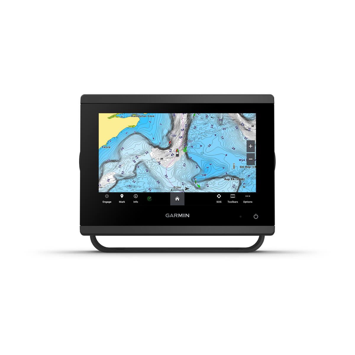
Garmin GPSMAP 743xsv
The do-it-all coastal chartplotter with sonar and charts in the box.
Who it's for: the owner of a 25 to 40 ft coastal boat buying their first or second chartplotter who wants one screen sized right for the helm, sonar and charts in the box, and the Garmin ecosystem they will not outgrow. This is what an honest friend with a 32 foot boat tells the friend buying their first chartplotter.
What we found: the 7 inch IPS display is sized for a 25 to 40 ft helm without the glare problems a 12 inch glossy panel brings under a bimini, ClearVü and SideVü sonar are built in so the bundle covers depth and bottom contour without a separate transducer purchase, and Garmin Navionics+ charts are preloaded. Sunlight readability is consistently praised across owner reviews. The recurring complaint across reviews is the SD card slot location once the unit is bezel mounted, which is real but solvable with planning. Garmin pushes regular firmware updates, and the 743xsv shows up in owner threads as still feeling current several years after release.
Bottom line: if you only buy one thing on this list, this is it. At $1,299 the chart ecosystem and the no-separate-transducer bundle are the reasons owners stop comparison shopping and just install it. You get the 7 inch IPS screen, ClearVü and SideVü sonar, Navionics+ charts preloaded, and a Garmin parts and firmware pipeline that keeps it current years after release. Want a bigger screen for less? The Raymarine Axiom+ 9 RV is the runner-up. Tight budget? The ECHOMAP 74cv runs the same charts at half the price.
- + 7 inch IPS display sized right for a 25 to 40 ft helm
- + ClearVü and SideVü sonar built in, no separate transducer to buy
- + Garmin Navionics+ charts preloaded out of the box
- + Sunlight readability consistently praised across owner reviews
- × SD card slot is awkward to reach once the unit is bezel mounted
- × Touchscreen slows down with heavy gloves, button only sibling models exist
- × Chart updates beyond the included year cost extra
Prices were accurate when we last checked and change often. The eBay figure is the lowest new listing we found, and its search can include newer or older models. We may earn a commission from these links, at no extra cost to you.
Runner-up: Raymarine Axiom+ 9 RV.
Raymarine Axiom+ 9 RV
The 9-inch RealVision-3D screen for $100 less than the Garmin top pick.
Who it's for: the coastal cruiser who finds a 7 inch display cramped at long ranges and wants the larger screen at the helm, and for whom the Garmin chart ecosystem and parts availability matter less than screen size per dollar. If a 7 inch display feels cramped and you want the larger screen, the Axiom+ 9 RV is the upgrade that actually costs less.
What we found: at today's price of $1,199 the Axiom+ ships with a 9 inch screen and a bundled RV-100 transducer for $100 less than our Garmin top pick. RealVision 3D, which gives you a sense of bottom contour and structure that flat sonar cannot show, is the feature owners actually use after the wow factor wears off. Lighthouse North America charts ship preloaded and are strong in the Northeast and Florida coasts, thinner than Garmin Navionics in the Pacific Northwest by recurring owner feedback. The Raymarine UI takes a week to feel natural if you have used Garmin before, and software updates require a Wi-Fi connection that does not always cooperate at the helm.
Bottom line: we still lead with the Garmin because the chart ecosystem and parts availability matter more than reviewers admit on a 25 to 40 foot boat. If those do not matter to you, the Axiom+ 9 RV is the better deal at today's $1,199, a 9 inch screen with the RV-100 transducer and RealVision 3D for $100 less than the top pick. Accept the week-long UI learning curve and the thinner Lighthouse coverage in the Pacific Northwest, and you get more screen for less money than anything else here.
- + 9 inch IPS display, the upgrade size people actually use
- + Integrated RealVision 3D sonar with the RV-100 transducer included
- + Lighthouse North America charts preloaded
- + More screen and $100 less than our top pick
- × Owners report Lighthouse charts thinner than Navionics on the Pacific Northwest coast
- × Raymarine UI takes a week to feel natural if you have used Garmin before
- × Software updates require a Wi-Fi connection that does not always cooperate at the helm
Prices were accurate when we last checked and change often. The eBay figure is the lowest new listing we found, and its search can include newer or older models. We may earn a commission from these links, at no extra cost to you.
Budget pick: Garmin ECHOMAP UHD2 74cv.
Garmin ECHOMAP UHD2 74cv
The Garmin coastal chartplotter at half the GPSMAP price, no network port.
Who it's for: the buyer who wants a Garmin coastal chartplotter at half the price of the GPSMAP line, runs one chartplotter, and mostly navigates rather than fishing structure. The 74cv is the budget pick that does not compromise on the things that matter for a coastal helm: it keeps the same Garmin UI and chart ecosystem as the 743xsv, so a later upgrade carries no relearning. It suits the owner who wants Garmin charts and a bundled transducer without paying $1,299.
What we found: a 7 inch screen at the right size for a 25 to 40 ft helm distance, US Coastal Navionics+ charts preloaded (not the Inland variant that ships on the cheaper 53CV), and a GT20-TM transducer bundled in the box. Owners praise the keyed assist touchscreen for working with wet, cold, or gloved hands. The honest limitation at this price is the sonar stack and the network: you get Garmin CHIRP and ClearVü but no SideVü, and there is no NMEA network port for adding radar or AIS later.
Bottom line: if your boat is one chartplotter and you mostly use the unit for navigation rather than fishing structure, the 74cv covers everything you actually need at $699, half the price of the 743xsv, including the GT20-TM transducer and US Coastal Navionics+ charts in the box. Accept ClearVü-only sonar with no SideVü and no network port for radar or AIS. If you plan to add radar or network multiple instruments down the road, step up to the GPSMAP line instead.
- + 7 inch IPS display sized right for a 25 to 40 ft helm at half the price of the GPSMAP line
- + GT20-TM transducer included in the box, no separate purchase
- + Garmin Navionics+ U.S. Coastal charts ship preloaded, not Inland
- + Same Garmin UI and chart ecosystem as the 743xsv, easier learning curve if you upgrade later
- × ClearVü scanning sonar only, no SideVü at this tier
- × Not network ready for radar or AIS like the GPSMAP line
- × Garmin refreshes the ECHOMAP line every 2 to 3 years, so the 74cv may not be the current SKU when you read this
Prices were accurate when we last checked and change often. The eBay figure is the lowest new listing we found, and its search can include newer or older models. We may earn a commission from these links, at no extra cost to you.
Also worth considering.
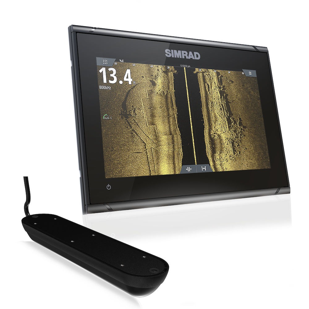
Simrad GO9 XSE
The only sub-$1,000 9-inch, the most screen-and-sonar per dollar if you'll learn a non-Garmin UI.
Who it's for: the coastal cruiser who wants the most 9 inch screen and bundled transducer per dollar and is willing to learn a non-Garmin UI to get it. The GO9 XSE is the only sub $1,000 9 inch chartplotter in this list.
What we found: at $899 it ships with the Active Imaging 3-in-1 transducer bundled in, covering down imaging, side scan, and traditional CHIRP without a separate purchase. C-MAP Discover Coastal charts ship preloaded, not Inland. The modular Simrad ecosystem means you can add Halo radar or a Bluetooth helm tablet later without swapping the head unit. The honest tradeoff is the UI: if you have used Garmin before, the Simrad menu system takes a week to feel natural, and owner reviews flag the learning curve consistently.
Bottom line: the reward is a 9 inch display with bundled transducer for $300 less than the Raymarine Axiom+ and $500 less than the equivalent 9 inch Garmin ECHOMAP UHD2 94sv. If the UI learning curve doesn't deter you, it is the most screen-and-sonar per dollar on the list.
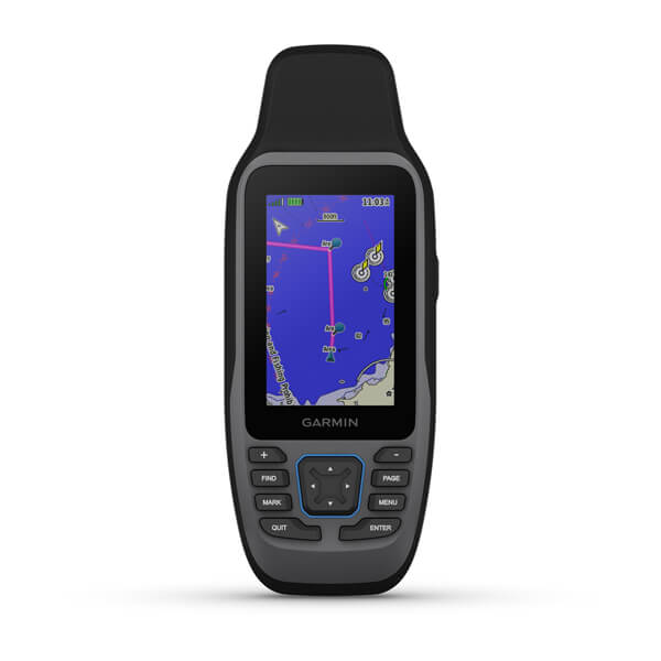
Garmin GPSMAP 79sc
The floating handheld backup for the day the helm electronics freeze, button-only by design.
Who it's for: the coastal cruiser who wants a floating, sunlight-readable handheld backup in the cockpit drybag for the day the helm electronics freeze. Every coastal cruiser eventually wishes they had bought this before their first helm electronics freeze.
What we found: it floats, it is sunlight readable, and BlueChart g3 coastal charts ship preloaded. It lives in a drybag in the cockpit, not the bottom of a drawer. The button interface feels dated next to phone apps, which owners flag as the one real complaint.
Bottom line: a button-only handheld is what you actually want when your phone screen is wet and your gloved hands cannot pinch zoom. It is the backup the boat falls back on, not the primary.
Skip this guide if...
You only run one familiar lake on weekends and the visibility is rarely below a mile. A $200 handheld GPS does this job and saves you about a thousand dollars. Pay for a chartplotter when you start running unfamiliar coast in fog or current, not before.
Don't bother with.
- × Skip No-name Amazon brand chartplotters at these price pointsChart data licensing fees are real. The bargain plotters skip them and lean on user contributed data that breaks in the worst weather. A chartplotter that fails when visibility drops is the one piece of gear you cannot save money on.
- × Skip Refurbished older ECHOMAP unitsA year old ECHOMAP is fine for fresh water but Garmin discontinues firmware support for older ECHOMAP generations faster than the GPSMAP line. Pay the extra for current model firmware and a longer support tail.
- × Skip Phone tethered Bluetooth GPS pucks as your primaryFine as a backup. Not what you want at the helm when current is setting you sideways and the phone screen is wet. The phone is the redundant device, not the one your boat actually navigates by.
How we picked.
Sources we read and the methodology we used
We don't run a lab and we don't have a boat to test these on. The sites that claim they do, mostly don't either. What we did was read the owner review signal across Amazon, Reddit r/boating, The Hull Truth, Practical Sailor, and the manufacturers' own support forums. Then we ranked by consistency of complaint and consistency of praise, not by the loudest review.
The shortlist: the brands actually sold on Amazon for this audience
The shortlist started with the brands actually sold on Amazon for this audience. Garmin, Raymarine, Humminbird, Lowrance, Simrad, Furuno, and B&G. We dropped Furuno because the offshore grade price tag is wrong for a 25 to 40 ft coastal helm. We dropped B&G as too sailing specific. We considered Humminbird and Lowrance and concluded both are stronger for fishing-first buyers than for coastal cruisers who navigate first and fish sometimes. The five that made the cut are the units a 30 foot coastal cruiser is actually choosing between when they walk into a marine electronics store.
What our scores mean, and what they don't
Our scores reflect how consistent the owner review signal is across hundreds of reviews, not lab measurements. A 9.1 means owners consistently agree the unit works as advertised in the conditions it is sold for. It does not mean we tested it ourselves.
FAQs.
Q01 Why does my marine GPS lose signal in fog or under a bimini?
+
Q02 What screen size do I actually need on a 30 foot boat?
+
Q03 Will my old transducer work with a new chartplotter?
+
Q04 Do I need NMEA 2000 to connect a GPS to other electronics?
+
Q05 Are tablet or phone GPS apps good enough for coastal cruising?
+
Q06 What's the difference between coastal and bluewater chartplotters?
+
Q07 Marine GPS keeps freezing or rebooting, what's wrong?
+
Q08 Chartplotter touchscreen unresponsive when wet, is that fixable?
+
Q09 How much power does a marine chartplotter draw, will it kill my battery?
+
Q10 How often do marine charts go out of date?
+
If you, then this.
- IF you're outfitting one helm on a 25 to 40 ft coastal boatGET Garmin GPSMAP 743xsv$1,299 →
- IF you want a 9 inch screen and the better dealGET Raymarine Axiom+ 9 RV$1,199 →
- IF budget matters more than the network-ready feature setGET Garmin ECHOMAP UHD2 74cv$699 →
- IF you want a 9 inch non Garmin alternativeGET Simrad GO9 XSE$899 →
- IF you want a handheld backup that floatsGET Garmin GPSMAP 79sc$315 →
Boat Gear: The Complete Guide
The whole-boat picture →Every system on a 20 to 45 ft coastal boat, organized in one place, with the one guide we trust for each.